File:Tokyo Metropolis Map (zh-hant).svg

呢個「SVG」檔案嘅呢個「PNG」預覽嘅大細:800 × 386 像素。 第啲解像度:320 × 155 像素|640 × 309 像素|1,024 × 495 像素|1,280 × 618 像素|2,560 × 1,236 像素|1,000 × 483 像素。
原本檔案 (SVG檔案,表面大細: 1,000 × 483 像素,檔案大細:313 KB)
.svg?uselang=yue)
摘要
| 描述 |
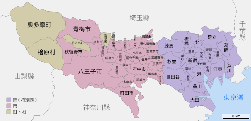
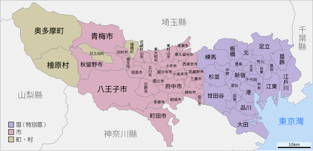
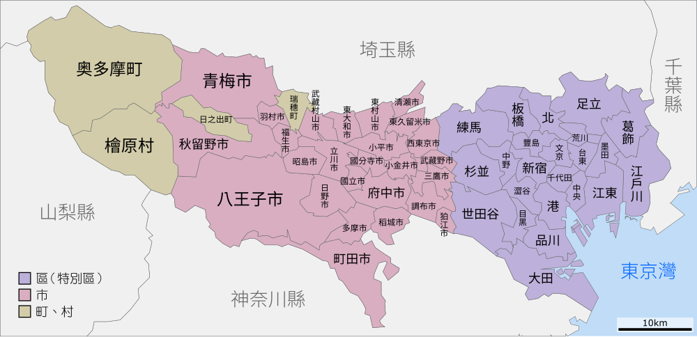
中文(臺灣):東京都行政區劃示意圖(不含島嶼地區) |
| 日期 | |
| 來源 | File:Tokyo Metropolis Map.svg |
| 作者 | Bigmorr (Source:Lincun) |
| SVG genesis | and with Inkscape. |
協議
This file is licensed under the Creative Commons Attribution-Share Alike 4.0 International license.
- 你可以:
- 去分享 – 複製、發佈同傳播呢個作品
- 再改 – 創作演繹作品
- 要遵照下面嘅條件:
- 署名 – 你一定要畀合適嘅表彰、畀返指向呢個授權條款嘅連結,同埋寫明有無改過嚟。你可以用任何合理方式去做,但唔可以用任何方式暗示授權人認可咗你或者你嘅使用方式。
- 相同方式分享 – 如果你用任何方式改過呢個作品,你必須要用返原本或者相似嘅條款發佈。
檔案歷史
撳個日期/時間去睇響嗰個時間出現過嘅檔案。
| 日期/時間 | 縮圖 | 尺寸 | 用戶 | 註解 | |
|---|---|---|---|---|---|
| 現時 | 2017年8月7號 (一) 19:50 | | 1,000 × 483(313 KB) | Bigmorr | User created page with UploadWizard |
檔案用途
以下嘅1版用到呢個檔:
全域檔案使用情況
下面嘅維基都用緊呢個檔案:
- zh.wiki.x.io嘅使用情況
- zh.wikinews.org嘅使用情況
.svg)